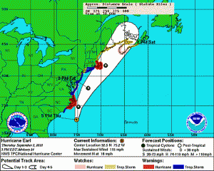
Beach erosion from Earl will eat into what little shoreline we have left
At best, Hurricane Earl will stay offshore as it passes Montauk some time late Friday, and will be significantly weakened from its south of Hatteras Category 4 intensity. But even without a direct hit, the likelihood is that eastern Long Island will experience hurricane-force wind gusts and a significant tidal surge. Forecasters are calling for Hurricane Earl to bring sustained winds of 40 mph (with gusts of up to 60 mph), heavy rains and possible flooding between 1pm Friday to the early overnight hours of Saturday.
The east end beaches are already in bad shape at Montauk State Park, Montauk Village, Gin Beach, Hither Hills and elsewhere thanks to last fall’s NorIda storm and the parade of nor’easters that have slammed long Island monthly, right through March, 2010.
And the dire prediction is that right behind Earl, tropical storms Fiona and Gaston are gaining muscle in the Atlantic.
Let’s hope that Earl and its followers are fast movers and–for the sake of our beaches and those in New England–executes some dramatic right hand turns out to sea. And no matter that the sun will come out on Saturday and Sunday. Don’t go near the water! Rip tides should be ferocious in Earl’s wake.

